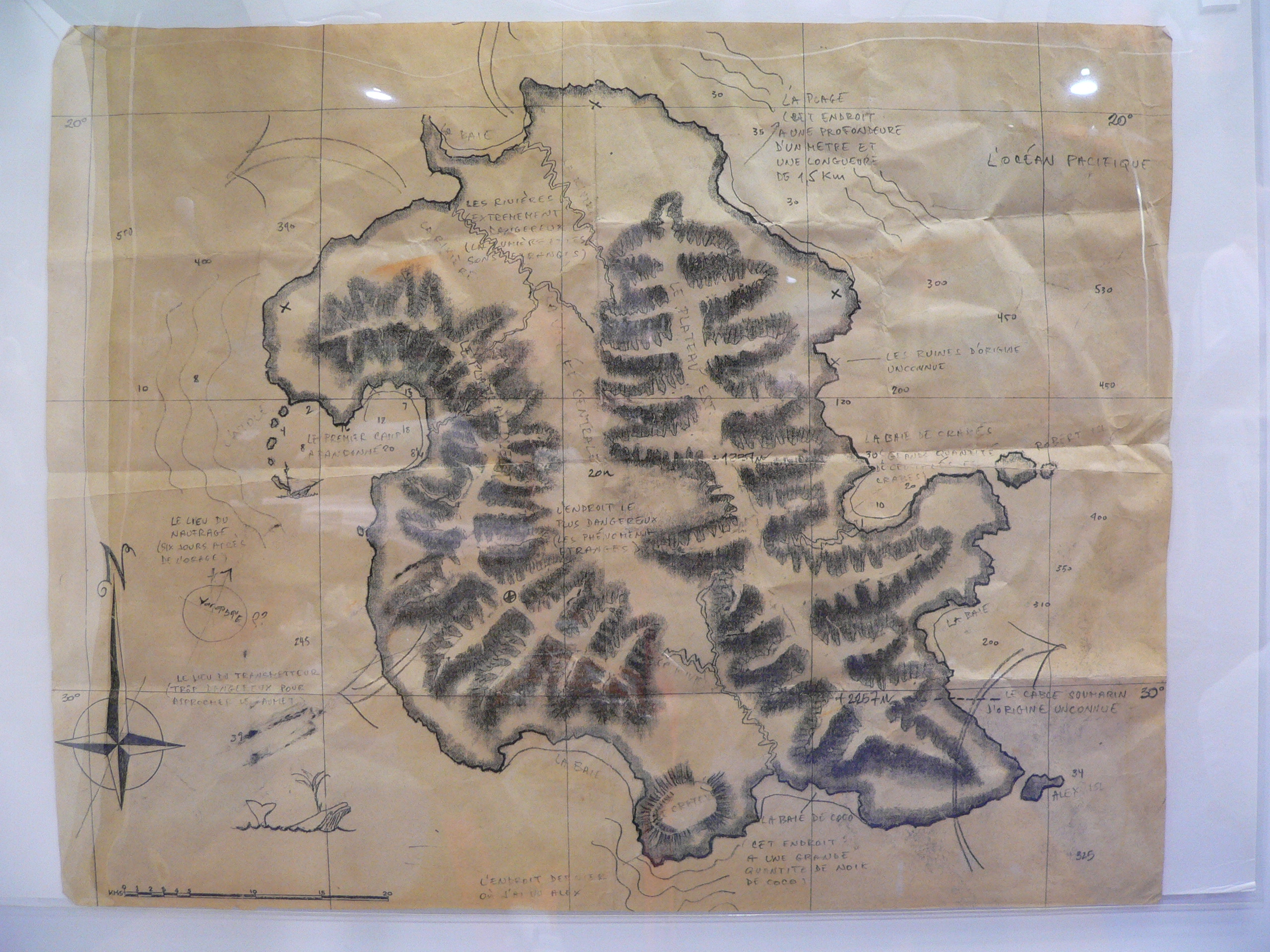
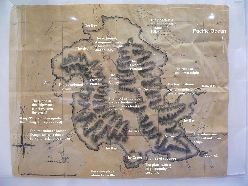
Though Rousseau's map had been seen before, never fully in one view, and never had all the French annotations been completely translated. Luckily for us, famed Lost fan Ryan Ozawa photographed the map and posted it online. Next up, I used some of the annotations we already had from Lostpedian Zholmboc, as well as from our page on the maps. Then, using the help of DarkUFO's chat crew, we carefully went through making amendments and solving lots of stuff that had never been seen before on previous screencaps of the map. A big thanks to Fivebretz, Jamielost, Elize34, Jeetus, KeepingPace, Chalovak, NewP and many others for all the help and eye-squinting at illegible French! Finally, we all came to agreement with our interpretations.
Click below for the full image. Let us know what you think - some areas like the bit about crustaceous crabs, where I saw Alex, and the magnetic north equation are highly subjective, and if anyone can get a better translation of it somehow, use the original image (or inverted) and let us know what you come up with so we can make amendments! For some of you though, this might be the first time you've seen an official drawing of the Lost Island. We hope you enjoy! And, once again, thanks to all the people who without whom this little project wouldn't have been completed.
I wonder if the resemblance to the island of Oahu is deliberate since the show is filmed there.
ReplyDeleteI don't remember The Crater...
ReplyDeleteThat's so awesome! Thanks.
ReplyDeletewas oceanic 815 on the bay of coconuts? I think they were on the south part of the island... Makes sense with the river's location, and with Sayid and Hurley's discovery of the cable on the beach for the looking glass east of this.
ReplyDeleteAm i right in assuming that the Mesa is the valley in the middle?
Can you guys post up the Blast Door Map next to it for some comparison? I know it's not perfect, but hey, it's not exactly like any locations on the island seem to make geographical sense anyway (e.g. travelling distance between camp and everything else).
This really is awesome. I tihnk it would really be cool to see some of these locations on the show (the bay of crabs, coconut bay, 1.5 km deep beach, extremely dangerous rivers, etc). This really is some amazing stuff!
ReplyDeleteWhere is the Losties beach? And which of the Islands is the Hydra Island?
ReplyDeleteBriiliant work. Thanks a lot.
ReplyDeleteHow did Rousseau manage to draw up this map and yet still never see the barracks, any of the Others, or the communication station?
ReplyDeleteAlso - how can they be auctioning these props off when they aren't done shooting the series? What happens if they realize they need this map again? Or Kate's toy plane?
Daniel Lee - I think there's a point marked on the map about "the most dangerous place" between the two mountain ranges... that could be the Barracks area... if so Rousseau probably stayed away from them. As for the auction, it's likely that they have duplicates of most props. I remember on Buffy how they had four of her Scythe weapon as it was an important prop (one metal for close-up, three rubber ones for fight scenes).
ReplyDeleteAnonymous - no idea where the Losties beach is. I think Robert Island is Hydra Island personally, as it is bigger. Also, Rousseau had another crater map also fully translated that marked the Island near the crater as just looking like rocks. What's also interesting is that on that map she marked the bay of coconuts as the bay of crabs... but on our new map it clearly says "cocos" and "noix de cocos" - meaning coconuts.
Bagman - no idea about the crater either. It could be where the Barracks was in that massive crater-like thing... but that makes little sense as the Other's camp is supposed to be far North near where the Tailies crashed (hence why they could launch an attack on them so swiftly).
The ruins of unknown origin is interesting - could be the four-toed statue, but doesn't make sense if you take the filming of when Sayid, Sun and Jin sailed the boat and saw it: they saw it on the starboard side while heading North, meaning it must be on the West or North-West of the Island. Could just be a production thing though.
ReplyDeleteAlternatively, it could be the small ruins we saw at the faux Others camp.
@Bagman: Couldn't "The Crater" be where the Dharma village USED to be (after Jack blew it up??) Who's to say when the Map was made? Time is so unstable on the island.
ReplyDeleteto follow-up about the question of auctioning off items when the show is not finished, the more recent post with the official abc videos has the guy in charge of the auction announcing it will not begin until may 2010...long after the props have served any purpose they have left.
ReplyDeleteMaybe the Crater realy is the location of the Barracks, since there is a dock which leads exactly to the Barracs, and on the map the Crater is located close to the shore.
ReplyDeleteVery cool!
ReplyDeleteI could be wrong but isn't the crater area where Desmond accidentally killed kelvin? There's a bay right next to it and I seem to recall it being a rocky area. If so that makes sense because it's near where the swan station should be
ReplyDeleteThis comment has been removed by a blog administrator.
ReplyDeleteThere is supposed to be a dormant volcano somewhere on the island, that could be the crater...
ReplyDeletethere is a hidden dino in the map ... http://img263.imageshack.us/i/tiltshift.jpg/
ReplyDeleteRousseau didn't draw this map. It was only in her possesion. Unkown how she obtained it though. The map was drawn around or before the 1850's and may have been a product of the Black Rock survivors. There was a more recent volcano that erupted to the east of the Bay of Coconuts after this map was drawn.
ReplyDeleteThe Losties beach camp was located on the Bay to the west (left) of the crater. The Hydra island was located to the north east of the island, as I recall.
I think the correct translation for "the rainy place where is saw alex" is actually :
ReplyDelete"the last place where i saw alex"
in fact, the french is more like :
"l'endroit dernier ou j'ai vu alex" which is a bit incorrect, "le dernier endroit ou j'ai vu alex" is good and mean : "the last place where i saw alex"
"rainy" is "pluvieux" in french
on the map the word looks more like "dernier" than "pluvieux"
some translations again :
ReplyDelete"the damned phenomena / freaks of nature"
---> the weird phenomena
"etrange" = "weird"
"the transmitter's location (dangerous trek...)"
----> "(too dangerous to reach the top [of the mountain])" (my guess for "trop dangereux pour approcher le sommet")
:)
The 815 crash-site was somewhere around "The Bay". The Swan is cradled somewhere between the mountain ranges, and the Barracks (And I think most Stations) are towards the top end of this map. (Perhaps the south rest left for the others? If you google search "map of the island in lost" or such, you can get maps which point out areas of signifigance.
ReplyDeleteThe 815 crash-site was somewhere around "The Bay". The Swan is cradled somewhere between the mountain ranges, and the Barracks (And I think most Stations) are towards the top end of this map. (Perhaps the south rest left for the others? If you google search "map of the island in lost" or such, you can get maps which point out areas of signifigance.
ReplyDeleteCan't believe how similar the islands shape is to this place!
ReplyDeletehttp://maps.google.com/?ie=UTF8&ll=-2.116447,32.8862&spn=0.059697,0.07493&t=h&z=14